Cube maps
Cube Maps and Their Use
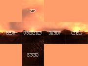 Example of all six sides of the cubemap laid out in their positions
as seen by the engine
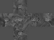
Example of all six sides of the cubemap laid out in their positions
as seen by the engine
 Example of all six sides of the cubemap laid out in their positions
as seen by the engine
Example of all six sides of the cubemap laid out in their positions
as seen by the engine
Cube maps (also known as environment maps) are comprised of a series of six images that correspond to the sides of a cube.
The purpose of which is to capture a 360 degree view of the player’s surroundings so that in game you can…
- fake the appearance of a sky or surrounding environment
- fake the appearance of environmental reflections
Storage and Naming Conventions
Cube map images are stored in the env folder.
Cube map images are named as follows…
[basename]_[direction].tgaWhere the basename is the name you will use to reference the cube map in your material shader , and the direction is the orientation of the camera.
The direction suffix can vary depending on what purpose you plan to use your cube map.
| SKY | REFLECTION |
|---|---|
| [basename]_up.tga | [basename]_py.tga |
| [basename]_down.tga | [basename]_ny.tga |
| [basename]_left.tga | [basename]_nx.tga |
| [basename]_right.tga | [basename]_px.tga |
| [basename]_forward.tga | [basename]_pz.tga |
| [basename]_back.tga | [basename]_nz.tga |
Capturing Images to Create New Cube Maps
Images can be captured from any application that provides you with the following controls…
- The ability to set the camera’s position to a fixed point.
- The ability to set the camera’s rotation, on all three axises, in 90 degree increments, with precision.
- The ability to set the camera’s field of view to 90 degrees.
From that point, all you need to do is capture six images where in each case the camera is oriented in a different cardinal direction (up, down, left, right, back, and forward).
The examples posted at the top of this page depict the correct orientation for each image if they were layed out side by side.
The console command envshot can capture the six needed images from within the game.
Editing Images
Some post editing may be nessicary depending on what field of view options were available and if the orientation of each image is correct.
Correcting Rectangular Images
If the field of view for your camera was 90 degrees both vertically and horizontally, the resulting captures would be square.
However, not all software allows for the adjustment of horizontal and vertical field of view in which case you’ll end up with rectangular captures because the screenshot captures more data lengthwise than heightwise or vice versa.
So long as the dimension in which you were permitted to adjust the field of view corrisponds with the smaller measurment across your image (height or width), then it should be possible to crop the image from the center and remove overlapping image data.
For example, if the height of your image is captured at a field of view of 90 and the width is larger than the height, then you can safely crop the sides from the center of the image.
Correcting Disoriented Images
Sometimes the rotational adjustments in an application do not cater well to the orientation expected in Doom 3 to make a proper cube map.
This means that occasionally it may be nessicary to rotate several of your images in 90 degree increments so when layed out they match like the example above.
Rearranging Cube Map Faces
Sometimes it is necessary to rearrange cube map faces for use with different export and editing tools. This often involves changing the naming convention of files and correcting the orientation of the images.
Some common corrections from application to application are documented below…
| Doom 3 | Quake 2 |
|---|---|
| _up or _py | _up and rotate 90 CW |
| _down or _ny | _dn and rotate 90 CCW |
| _left or _nx | _lf |
| _right or _px | _rt |
| _forward or _pz | _ft |
| _back or _nz | _bk |
Fixing Seams or Drawing a Cube Map from Scratch
It is possible to edit a cubemap as a single entity instead of working with the individual images by using a program called SkyPaint .
The program is designed to work as a front end to any image editing application.
It works by allowing you to select a portion of your cube map by positioning a viewport in 3D and then sending this view to your image editing application.
Once you’ve finished with your manipulation of the image, you send it back to SkyPaint and the program sorts out what pixels corrispond to what image in the cube map.